“AgriNerds” might have a funny name but the startup is serious about preventing wild birds from spreading the deadly avian influenza virus. Using a range of different technologies, AgriNerds has created a tool to predict the movements and concentration of waterfowl in close proximity to commercial poultry.
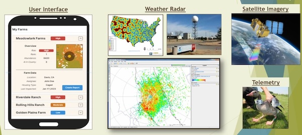
AgriNerds was co-founded by University of Delaware wildlife ecology professor Jeff Buler and a group of UC Davis affiliated engineers and veterinarians. CEO Maurice Pitesky says he first connected with Buler after reading a paper he wrote about how to make predictive models of waterfowl movement using radar, telemetry, and satellite imagery.
“Ever since radar was discovered before World War II, people knew you could use it to identify the location of birds like waterfowl, ducks, and geese,” says Pitesky. “It wasn’t until the last decade where people like myself and Jeffrey Buler started thinking about how to use the technology in more of an applied setting instead of an academic exercise.”
As most are probably aware by now, the bird flu outbreak that began in 2022 has devastated the poultry industry. So far, the disease has affected more than 162 million commercial, backyard and wild birds — including roughly 10% of all U.S. laying chickens in the last three months. It’s also spread to other animals, including milk cows in nearly 1,000 herds nationwide. Humans working in close proximity to infected animals have been sickened as well.
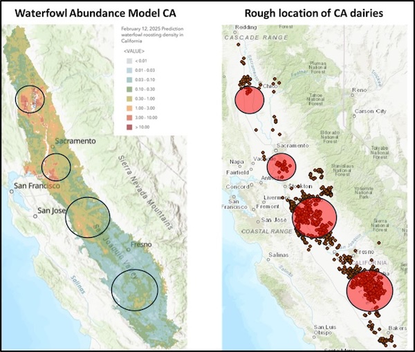
Waterfowl are a major reservoir for bird flu. They can carry avian influenza viruses in their intestinal tract and spread them through their saliva or excrement. In many cases wild birds show no symptoms of the virus themselves.
“It’s kind of like whack-a-mole,” explains Buler. “When it pops up, we cull that flock, hoping that will prevent the spread. But it doesn’t. And the fact that the virus is also in wild birds, like waterfowl, which we can’t really control means there is a reservoir for the virus outside of the poultry industry.”
Leveraging Next Generation Weather Radar (NEXRAD) data from the National Oceanic and Atmospheric Administration, telemetry (radio tags to track wild birds), satellite imagery, and ground based environmental data, AgriNerds uses AI and machine learning to produce daily predictive models of waterfowl locations via the “Waterfowl Alert Network.”
Buler, the primary developer of the network, calls it “the world’s first SaaS (software as a service) based predictive tool for waterfowl mapping and abundance.” U.S. farms sign up and subscribe to the platform to receive alerts. Using their location data, the Waterfowl Alert Network quantifies each farm’s likelihood of exposure to waterfowl, and sends the farms daily alerts via email.
The tool costs a monthly fee of $50 per farm. Matt Hardy, a waterfowl ecologist at AgriNerds and an alumnus of UD’s Wildlife Ecology M.S. program, said the company currently has about 1,500 farms in 25 states subscribed to its platform. Learn more at AgriNerds’ website HERE.