I wanted to share that we are starting a new relationship with our good friend Gary Lezak at Weather20/20. Gary worked as the Chief Meteorologist at KSHB 41 in my hometown of Kansas City for 23 years, from 1999 to 2022, and has been doing some very interesting research the whole time. We believe his approach goes beyond what the weather forecasting industry has trusted in for over a century and think everyone should take a look for themselves and decide if this is a tool you need in your box for making better business decisions. Gary will be contributing to our report each Monday with his insights.
Weather forecast models have been using the same atmospheric flow calculations since 1922. It’s a system rooted in plugging a set of initial conditions into physics formulas and then seeing where they may lead over time in forecast output. This physics model is used by pretty much everyone in weather forecasting as they try to simulate and predict the conditions of the entire atmosphere. But they can only approximate those conditions. Although modern technology has allowed meteorologists to use better initial conditions, there are still errors that compound over time, rendering their longer-range forecasts useless. It’s these errors that limit these models from having any accuracy beyond 14 days. So is there a better way?
Historical insights from as early as the 1940s say that there is. Jerome Namais, once the head of the long-range forecasting division of the Weather Bureau, now the National Weather Service, proposed that the signals of the upcoming winter’s patterns were evident by November, allowing for reasonably successful long-range forecasts for the season. Namais discusses how there is enough information by the mid-fall months, November, to make accurate predictions of what will happen the next winter. He also discusses anchor troughs and ridges that become established in the fall and that an index cycle lasts up to weeks at a time.
It’s worth noting that Namais’s work put him in some pretty high-level policy decision-making circles, including the crucial role he played in weather forecasting for the Allies during World War II, particularly for the invasion of North Africa. In 1971, Namias joined the Scripps Institution of Oceanography, where he established the first Experimental Climate Research Center. His work significantly influenced domestic policy during the Arab oil embargo of 1973 by accurately predicting warm weather.
Namais was definitely onto something in the 1940s and 1950s before computer technology evolved. Fast forward to the 1980s, and we see a further breakthrough by Gary Lezak, who discovered that the weather pattern is not random but cyclic. This discovery is so precise that it enables predictions weeks to months ahead, pinpointing the development of winter storms, the location of severe weather outbreaks, and even the paths and landfalls of hurricanes. This innovative methodology and technology have been named the Lezak Recurring Cycle or LRC, a name given to it by KSHB-TV bloggers in 2002 while Gary was working for the station. The LRC provides the weather forecaster with a great tool to help in the prediction of every day’s weather for all locations of the world from 1 day to up to 350 days out.
For the agriculture sector, where the stakes are directly tied to weather conditions, the LRC offers a groundbreaking tool. This model provides farmers and agribusinesses with unprecedented insights into future weather patterns, granting them power to plan and respond with an accuracy previously deemed impossible. With the LRC, the ability to anticipate weather can transform a potentially catastrophic season into a successful harvest.
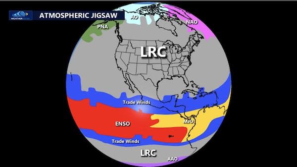
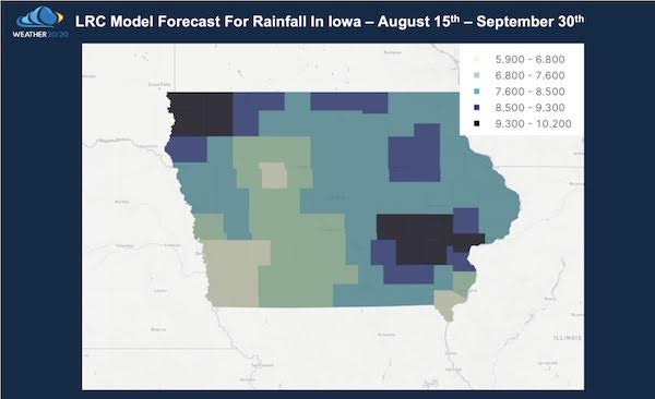
While various factors contribute to accurate forecasts, the LRC is the centerpiece of our atmospheric puzzle. In the image below, you’ll see one of the LRC Forecasts for the State of Iowa as we approach harvest. These forecasts, from the Weather 20/20 Vision Dashboard, ranging from picking which county your farm is in, to the state level, or picking any nation in the world, the LRC model provides the predictions for up to nearly a year ahead to help you plan.
Understanding weather patterns is crucial to farmers. The LRC provides deep insights into weather trends, such as accurately predicting when a drought may end or when to expect excessive rainfall. These forecasts are essential for scheduling critical farming activities that ensure a successful year. One recent example comes from the Weather 2020 Intelligence Report subscriber, Marvin Piotter from South Dakota, who has firsthand experience with the benefits. Marvin stated that his corn was so tall on July 1st because of the LRC and Weather 20/20 predictive insights. Many farmers didn’t get their corn planted and we got 600 acres in because of our trusting the forecast. The photo below is of corn grown in northeast South Dakota.
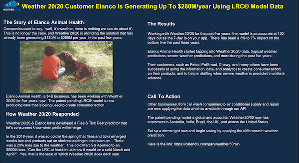
As I mentioned above, Weather 20/20 is going to start providing our readers with some broad-ranging weather forecasts and commentary moving forward. If you are interested in learning more specifics for your particular area or what other weather-related tools they have available, Click HERE


It’s actually nuts that farmers would co-operate with meteorologists to max farming gains, I never thought of that