
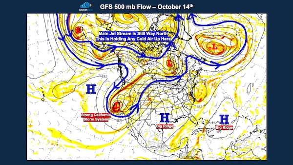
While no forecasting system is perfect, the LRC or the Lezak Recurring Cycle provides the data, structure, and technology to make Weather 20/20 the only known method in meteorology capable of predicting, weeks to months in advance, when and where severe weather will occur, where tropical systems will form, and where winter storms will develop. We’re now at a pivotal moment in the developing cycling weather pattern that will define the year ahead. I’m not sure I want to call this Exhibit A, but take a look at the impressive storm system hitting Southern California this morning, you can clearly see the circulation centered just offshore.
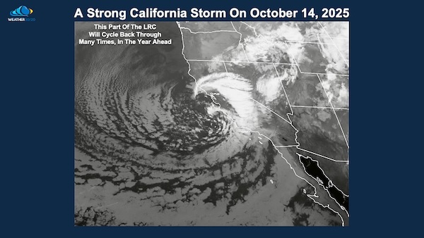
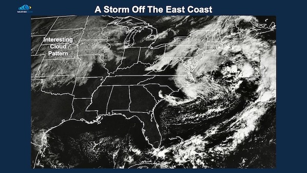
This part of the weather pattern will be one to watch, it will cycle back many times in the year ahead. So, when we’re looking at another major storm hitting the West Coast a few weeks from now, don’t be surprised when I show you the comparison to this exact setup. At the same time, there’s also a storm system off the East Coast, with a broad cloud shield stretching from the U.S./Canada borders southward into northern Oklahoma. This evolving setup is already giving us valuable clues about how the new LRC is forming and how the jet stream is organizing across North America.
It’s important to remember we’re only about 10 days into the beginning of this year’s LRC. Imagine if this turns out to be a longer cycle, around 50 days or so. That means we still have roughly 40 more days to observe before drawing any major conclusions. If the cycle is closer to 60 days, then that means we have 50 more days to learn a lot more. So, as I always say, let’s have a lot of patience. The pattern is still transitioning from last year’s cycle into the new one, and this is the period when the atmosphere begins to organize itself into the structure that will drive our weather for the year ahead.
Drought conditions extend from Missouri to Ohio, and a large area out west, although that western region just got some good relief. Here is the drought monitor from the beginning of this year’s LRC that we will use to compare in the weeks and months ahead.

Risks of severe thunderstorms are already beginning to show up as the new LRC takes shape and as the 2025–2026 LRC begins to organize, we’ll soon be able to identify the new set of recurring segments and beyond, that will define this year’s major storm and severe weather windows. This potential setup is being fueled by energy from the California storm system, which will move out into the Plains over the next several days. As that energy interacts with warmer, more humid air from the Gulf of Mexico, the ingredients for severe thunderstorms, including damaging winds, hail, and possibly tornadoes, will come together across portions of the central United States. This system may represent one of the first major storm signatures of the new 2025–2026 LRC, setting the stage for what we’ll see repeating through the rest of the cycles in the year ahead.
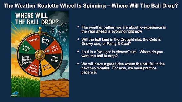
The roulette wheel of weather is still spinning and the ball hasn’t dropped yet, so where will it fall this year? I’ve seen many other winter forecasts that show a single static map trying to capture an entire season or even a full year of weather. But as we know, the atmosphere doesn’t work that way. This is where Weather 20/20 stands apart. Using our Vision Dashboard, we can look up to a year ahead, day-by-day, week-by-week, and month-by-month, tracking the pattern as it evolves in real time. Our extensive winter forecast will be released during the first week of December. For now, we know the new LRC pattern is actively setting up above us right now, forming the foundation for everything we’ll experience in the months ahead.
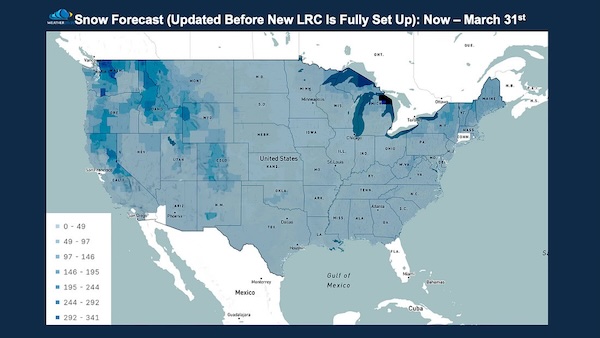
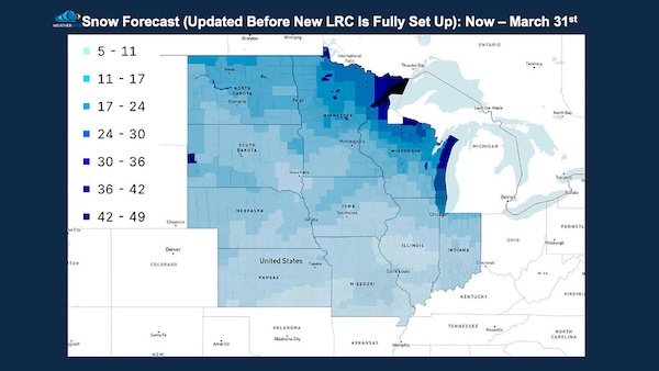
The LRC model is just now beginning to incorporate data from the new 2025–2026 cycling pattern, while still being strongly influenced by last year’s pattern. Over the next few weeks, this new data will continue to update as the fresh atmospheric cycle becomes more dominant. Once that happens, we’ll be able to look much farther ahead with increased precision and confidence.Below are some of the early snowfall forecasts generated by the model and our maps will update every Saturday night as the new 2025–2026 pattern evolves, giving us an increasingly accurate picture of where snowpack is likely to build, and where it may come up short. For now, though, let’s have a little fun with it. Here’s the early outlook from the Weather 20/20 model, a first glimpse of how the new LRC may shape this winter’s snow story.
As the new 2025–2026 LRC continues to develop, we’re entering one of the most exciting times of the year for weather analysis. Every storm, every shift in the jet stream, and every new data update is helping us uncover the blueprint of the pattern that will guide the months ahead. If you’d like to learn more about how Weather 2020 and their dashboard are providing our growers more lead time to making better business decisions, click HERE.