As we move through mid-May, the LRC recurring pattern has been tracking all season and continues to deliver right on schedule. This is a crucial time for the agricultural community, and the LRC provides growers a unique edge, not just in knowing what weather is coming, but when and where it will matter most. We wanted to pass along the next impactful precipitation windows from our forecasting friends at “Weather 2020” and examine how this cycle aligns with earlier rounds of severe weather, as well as sharing what farmers should watch for in the final stretch of planting and early crop emergence. Timing is everything in agriculture, and this week, the pattern is delivering signals worth paying attention to.
May is a critical development month for winter wheat, especially in Kansas, Oklahoma, Texas, and parts of Colorado. Crops are either in heading or grain-fill stages, which means moisture is essential, but too much rainfall or prolonged saturation can introduce new challenges. Persistent moisture may increase the risk of head scab and rust diseases, particularly if storm systems coincide with flowering and delays in dry-down can postpone harvest and introduce quality concerns in low-lying or poorly drained fields. Western Kansas, one of the drier regions this season, just received some beneficial moisture, improving short-term conditions. However, a potential drying period is approaching, and producers in that area should monitor closely for signs of stress resurgence, particularly in non-irrigated fields.
Meanwhile, farther north, a remarkable alignment is emerging between both the GFS and the European AI-enhanced forecast models, showing 2″ to 10″ of rain across the Dakotas in the coming week. This reinforces what the LRC has already suggested, that we’re entering a stormier phase with elevated precipitation risks across key growing regions. You can see the graphics below showing both models.


One important trend to watch in the latest rainfall forecasts is how precipitation aligns with areas we’ve highlighted for drought concern. The core region still facing critical drought conditions is also the one area where rainfall totals remain lower in the short- and medium-range outlooks. While adjacent areas are projected to receive meaningful moisture, this pocket continues to show up on the drier side in both the GFS and ECMWF model guidance.
We recently showcased a map-to-map comparison that highlighted how remarkably on schedule the current LRC cycle remains. Here are those two maps again as a powerful reminder of the consistency and predictability of this year’s pattern.


As we approach summer, one key transition is already underway, the weakening and northward shift of the jet stream. While this shift typically becomes more pronounced in late May and June, the process actually began subtly in February and March. We’re now seeing more obvious signs as the atmosphere transitions toward its summer configuration. The energy is still strong enough to produce potential major severe weather outbreaks and tornadoes well into June, with these risks fading as summer begins. There is still severe weather over the summer, but just not usually as organized, as widespread, or as deadly as earlier in the spring.
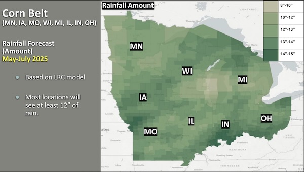
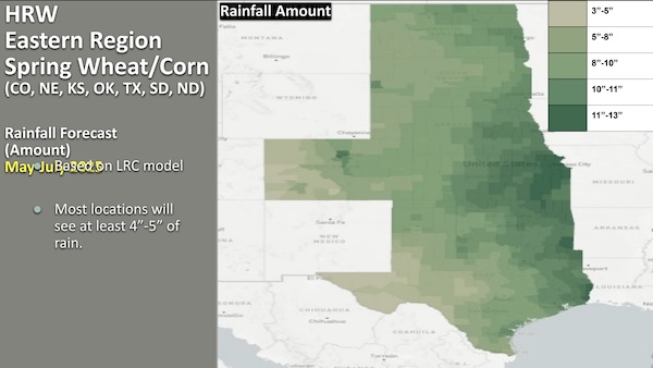
As we move through mid-May and into the heart of the growing season, the LRC continues to provide clear, actionable insight into what lies ahead. From the recent dry spell that aligned perfectly with planting progress, to the stormier window now developing, the pattern is unfolding exactly as forecasted. The last two graphics below show the longer term forecasts for rains across the growing areas through July. We will be going into more detail on those numbers in one of our next articles.
We’ve been hearing from a number of our grower clients who executed their planting based on the “LRC forecasts,” and were extremely happy they had great sucess during the designated windows and avoided delays while getting nice spring rains to start the crops. If you would like to learn more on why a growing number of farmers are relying on the long term forecasts from the LRC to reduce their downtime, replants, and manage their resources more efficiently, Click HERE.