As of today here in early-September, the calendar still says “summer” for another week or so, and the next few days high temps are supposed to be 80+ degrees all across the Midwest. However, the first freeze of the season may be here before you know it. In fact, parts of the northern Rockies have already had their first freeze, as well as accumulating snow. With this in mind, I think it’s interesting to look at when the first freeze typically occurs all across the nation. It’s important to note that these are simply median dates, and different weather patterns each fall can make your first 32-degree temperature occur much earlier or much later than what is shown on the maps and data below.
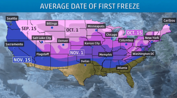
September 15: The average first freeze occurs sometime around Sept. 15th for much of the Rockies and Intermountain West as well as parts of the northern Plains and upper Midwest (closer to the international border). Additionally, some inland areas of the upper Great Lakes also see their first freeze around Sept. 15th each year. It’s also worth noting, western Wyoming, western Montana, Idaho, and eastern Oregon will see their first freeze before Sept. 15th as of late. Keep in mind, last year Denver didn’t see its first freeze until Oct. 13th, but it was as early as Sept. 8th in 2020.
October 1: A large swath of the West and Midwest sees their first freeze sometime near October 1st. This includes much of the Great Basin, northern Plains, upper Midwest and parts of the upper Great Lakes. Most of the Adirondacks and Catskills in New York experience 32-degree temperatures around October 1, along with the Appalachians from west-central Pennsylvania down into eastern West Virginia. The majority of New England also gets its first freeze around October 1st, on average.
October 15: A large area of the country averages the first freeze in mid-October. Parts of the northern Southwest, much of the central Plains, parts of the upper and mid-Mississippi Valley, much of the Great Lakes, the northern Ohio Valley and a large swath of the Northeast generally reach 32 degrees around Oct. 15. The Great Smoky Mountains in eastern Tennessee and western North Carolina also have their first freeze near Oct. 15, as well as the Shenandoah Valley of western Virginia and much of West Virginia.
November 1: Parts of the Southwest, southern Plains, mid-Mississippi and Ohio Valleys, and mid-Atlantic don’t see their first freeze, on average, until Nov. 1. The major cities along the Interstate 95 corridor, from New York City to Philadelphia, Baltimore and Washington D.C., are included in not seeing 32-degree temperatures until about Nov. 1. This is due to the urban heat island effect, keeping cities warmer than their suburbs overnight.
November 15: Parts of Southern California, the Southwest, southern Plains, lower Mississippi Valley and Southeast don’t see their first freeze until November 15 on average. The southernmost portions of these regions may not see 32-degree temperatures at all, such as southeastern Texas, Louisiana, southern Mississippi and Alabama, the coastal Carolinas, southern Georgia and all of Florida.