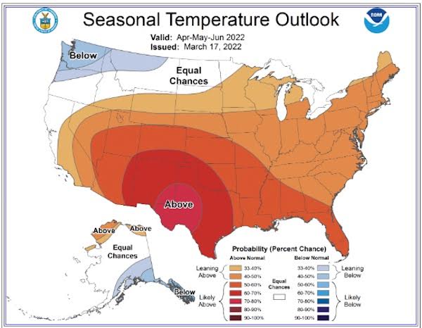
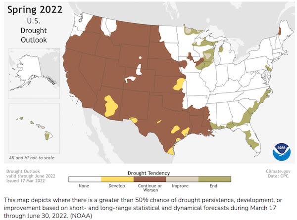
NOAA recently released their revised U.S. Spring Outlook and for the second year in a row forecasters predict prolonged persistent drought in the West with below-average precipitation most likely. NOAA is also forecasting above-average temperatures for most of the U.S. from April to June. With nearly 60% of the continental U.S. experiencing minor to exceptional drought conditions, this is the largest drought coverage NOAA has seen in the U.S. since 2013!
You might recall, 2013 was characterized by large areas of dry weather which were more than counterbalanced by large areas of wet weather where for six months, 10% or more of the country experienced very dry conditions, while 10% or more of the country experienced very wet conditions. I’m wondering if we might see something similar this year with the eastern portion of the corn belt staying wet and some of the western regions drier than normal?
NOAA is seeing an elevated risk of wildfires across the Southwest and southern Plains and north to the Central Plains, especially when high winds are present. Drought conditions in the Southwest are unlikely to improve until the late summer monsoon rainfall begins. Below-average precipitation is forecast for portions of the Central Great Basin, Southwest, Central and Southern Rockies and Central and Southern Plains, eastward to the Central Gulf Coast.
Above-average amounts of precipitation are most likely in portions of the Great Lakes, Ohio Valley, mid-Atlantic and the west coast of Alaska. This is expected to create a minor-to-moderate flood risk throughout much of the eastern half of continental U.S., including the Southeast, Tennessee Valley, lower Mississippi Valley, Ohio Valley, and portions of the Great Lakes, upper Mississippi Valley, and middle Mississippi Valley. On top of that, updated data that’s come in from the late fall and winter precipitation, which I’m told saturated soils and increased streamflows, has elevated a major flood risk potential for the Red River of the north in North Dakota and moderate flood potential for the James River in South Dakota.
It’s worth mentioning that more than half of the U.S. is predicted to experience above-average temperatures this spring, with the greatest chances in the Southern Rockies and Southern Plains. From what I understand, the only areas expecting to see below-average temperatures will most likely be in the Pacific Northwest and southeast Alaska.
Weather will obviously play a significant role in our production this season. Add to the mix all the geopolitical uncertainties and growers will really need to keep the risk-management hat on tight. I suspect there could be some real opportunities to see higher prices as some of these weather and war “wild-cards” start to get flipped over. Remember, as the cards are flipped over the game can quickly start to change. Make sure you have a plan in place and are willing to execute. (Source: noaa.gov)


