Whether or not the new markets and revenue streams that are being promised to producers for sequestering carbon will emerge and operate properly remains to be seen. What we do know is that as the industry continues to move in that direction, scaling up the ability to know for sure what’s in your soils will have to be overcome. Cloud Agronomics, founded just two years ago is hoping to do just that from high in the skies.
Keep in mind, one of the challenges facing anyone looking to profit from carbon farming is having to take the time to gather up a sufficient number of physical soil samples, ship them off the lab, which can be expensive and time-consuming and still may not provide a holistic picture of soil health or carbon content. From what I understand, Cloud Agronomics is the first private company to scale this lab-grade measurement capability across millions of acres of farmland by reinventing how hyperspectral data is calibrated, processed, and stored in the cloud. I’m told their efforts have resulted in creating datasets that contain up to 300x more information per pixel than satellite imagery.

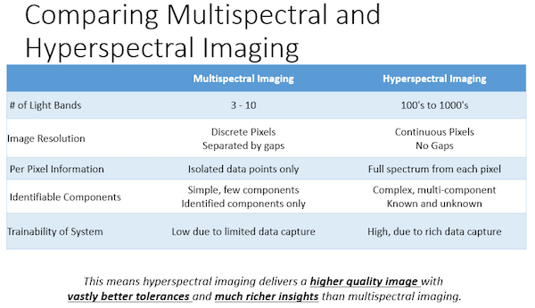
According to CEO Mark Tracy, who also was an exec at Cargill and Indigo Ag, Cloud Ag took a technology partly developed by NASA and realized that it could be applied to plant and soil health and that it could be used for diagnosing disease. Keep in mind, the majority of imaging being used by farmers is often advanced non-hyperspectral, meaning it simply tells farmers the measure of green-ness, leaving them without prescriptions or answers. Getting the technology from the lab to the fields proved a hefty challenge when you consider that it was like taking the line scanner out of a copier, putting it 8,000 feet above the document you want to copy, flying it at 200 miles per hour and expecting to get something useful out of that. I’m told the secret lies in the breakthrough calibration across many bands.
This past Spring, Cloud Ag took physical soil samples across 11 different states in the US, coming from diverse locations and climates in Texas, as far north as Minnesota, Indiana in the east and west to Colorado. At the same time, they also flew over the locations with their hyperspectral imaging, and that was the basis of showing our model has less than a 10% error rate. Execs at Cloud Ag are aware that it will take time to build confidence in their solution, a solution that if successful will certainly disrupt the space.

Cloud Ag intends to use a B2B model, partnering with ag retail and coops, with customers being charged per acre for the ground being covered as well as for the type of analysis being provided. I think this once again shows us there is no corner of ag that is not being impacted by technology. This is definitely something to keep an eye on and could be a game-changer in this space moving forward. You can learn more about Cloud Ag HERE. (Source: Agfunder, wiki)