Abnormally high temperatures and insufficient moisture is creating the perfect “flash drought” conditions across key US growing regions. Flash droughts, unlike conventional droughts, have an extremely rapid onset, developing as fast as just 5 days in some instances. They are also extremely hard to predict and pinpoint with any sort of consistent accuracy but scientists have become better at understanding the mechanics that bring them on.
The classic view of droughts is that they are typically slow to develop, according to Ben Cook, a climate scientist at the NASA Goddard Institute for Space Studies. “But like heavy rainfall or floods or heat waves, flash droughts are very quick — all of a sudden, you’re in it.” According to a study from University of Texas Austin, about 34%-46% of flash droughts over the last 21 years came on in about five days. The rest emerged within a month, with more than 70% developing in half a month or less.
As the name suggests, flash droughts are short-lived, usually lasting only a few weeks or months. But when they occur during critical growing periods, they can cause disasters. For example, in the summer of 2012, a flash drought in the central United States caused the corn crop to wither, leading to an estimated $35.7 billion in losses. It’s also worth noting that research shows between 5-10% of flash droughts transitioned to the highest drought category given by the U.S. Drought Monitor: Exceptional Drought or D4.
Flash droughts are relatively new to science, with the advancement of remote sensing technology during the past couple of decades helping reveal instances of soil rapidly drying out. Mark Svoboda, the director of the National Drought Mitigation Center and originator of the term “flash drought,” said the advancement in drought-detecting technology and modeling tools has led to growing awareness of the influence and impact of flash droughts. He said the next big step is translating this knowledge into on-the-ground planning. One goal is to pinpoint early indicators that might help forecast these events and give more warning before they hit.
Unlike slow-evolving drought, which is caused by a decline in precipitation, flash drought occurs when low precipitation is accompanied by abnormally high temperatures (e.g., heat waves), high winds, and/or changes in radiation. These sometimes-rapid changes can quickly raise evapotranspiration rates and remove available water from the landscape. Currently, evapotranspiration rates are one of the strongest indicators of flash drought.
Evapotranspiration is the loss of water from the soil both by evaporation from the soil surface and by transpiration from the leaves of the plants growing on it. Factors that affect the rate of evapotranspiration include the amount of solar radiation, atmospheric vapor pressure, temperature, wind, and soil moisture. Evapotranspiration accounts for most of the water lost from the soil during the growth of a crop.
Geographic differences and climate patterns also impact the development of flash drought. In contrast with conventional drought—which may occur throughout the year at any location—flash drought typically occurs during warm seasons in the central United States. Widespread flash drought in the US is also often tied to La Niña events, which is currently present for a third year in a row.
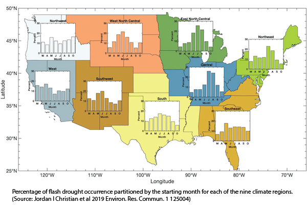
A recent study supported by the National Oceanic and Atmospheric Administration (NOAA) and US Department of Agriculture (USDA) found that between 1979–2016, flash droughts in the western US occurred more frequently in May and June, with the Northwest climate region seeing an additional peak at the end of the growing season. In contrast, flash drought frequency across the central and parts of the eastern US peaked in July and August. The frequency of flash drought in the Southeast region generally peaked in May. For all climate regions, flash drought intensity tended to increase toward the beginning of the growing season and then decrease. In general, regions that undergo seasonal swings in humidity – such as Southeast Asia, the Amazon Basin, and the East Coast and Gulf Coast of the United States – tend to be flash drought hot spots.
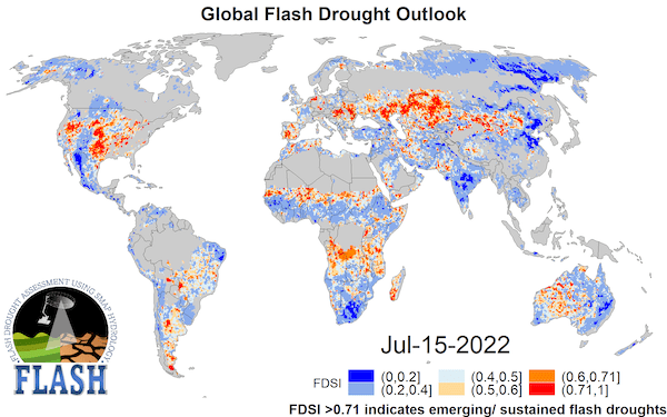
There are a couple of tools for early flash drought detection currently being tested. One from Texas A&M uses NASA’s Soil Moisture Active Passive tool. Known as “FLASH” – FLash drought Assessment using SMAP Hydrology – the tool is designed to provide a near-real-time global flash drought outlook using surface soil moisture from SMAP. Check it out HERE. Another is the Evaporative Demand Drought Index (EDDI). NOAA says a particular strength of EDDI is in capturing the precursor signals of water stress at weekly to monthly timescales, which makes EDDI a potent tool for drought preparedness at those timescales. EDDI also uses the same classification scheme as the USDM to define drought conditions, so it is easy to read EDDI maps. Learn more HERE. (Sources: Discover Magazine, Drought.gov, NOAA, Texas A&M)


